

Roy B
-
Joined
-
Last visited
-
Days Won
188
Everything posted by Roy B
-
Continued from above: Come with me and let’s have a look around. If weather permits there is usually one of the exhibits outside on the car park. When I visited it was a very smart MAN that had its day out. Inside near to the entrance is a Morris Minor van with hoods over the headlights. I don’t recall ever seeing these on a Moggie van before. Two engines from the 1960’s are on stands. The first is a Rootes Tilling Stevens prototype dating from 1966. It never went into production and there are only four left in existence. It is a four cylinder two stroke diesel. Each cylinder carries two pistons horizontally opposed to each other. It was a development of the highly successful three cylinder predecessor which powered many Commer vehicles. Eight of these engines were installed in Commer’s as a trial. Between them they completed more than one million miles and gave outstanding performance, reliability and fuel consumption. However, in 1967 Rootes became part of the Chrysler Corporation who promptly closed the factory and gave instructions to remove and destroy the test engines that were fitted into the vehicles. The other engine is a gas turbine from 1968. Leyland was at the forefront in the design and build of gas turbines for possible use in hgv’s. During the 1950’s, lightweight gas turbines had been developed for use in several makes of car. However, none made it into production. Rover Cars was the acknowledged leader in this field. They had been involved with Sir Frank Whittle in the development of his jet engines. Leyland used the same principle as Rover when designing this much larger engine for use in experimental hgv’s. Several prototypes were built and placed with petroleum companies for evaluation but none went into production. They gave an excellent power to weight ratio with less moving parts but were very expensive to produce. They were not economical unless used at a high constant speed. We now come to the Albion Claymore. The chassis of this truck was supplied new by A.McAra Ltd of Broughty Ferry. They also had a copper works in Dundee which supplied many of the fittings to the famous ship ‘Discovery’. Ernest Shackleton was a regular visitor to the works. Another prominent visitor was a poet by the name of McGonnegal who had little copper snuffboxes made to attach to his clothes. He always spoke in rhyme and must have been a great character. George Robbie of Dundee were the purchasers and used the Albion to carry Jute sacking from the mills in Dundee. It was taken off the road in 1965 and left to decay until bought by Longton Coachcraft in 1967. When restored it was re-registered. It has completed many rallies, Land’s End to John-o-Groats, London to Brighton, and the Trans Pennine. Between 1992 and 2001 it was taken off the road again and painted in its current livery. It is still owned by Longton Coachcraft. Next is the Popemobile. When Pope John-Paul visited Britain in 1982, British Leyland supplied the four vehicles that were used to transport him around the UK. Two were based upon the Range Rover chassis, and two upon the Constructor 6 tipper chassis. The Constructor was chosen for its renowned off-road capability and acceleration if an emergency arose. The sheer size of the vehicle meant the Pope would be more comfortable and not as cramped as in a car based chassis. The increased height would also allow more people to see him. Bullet proof glass and under-floor armour were two security measures incorporated into the design. With the exception of the reg plate both Constructor chassis were identical. The engine was a Leyland 410 diesel giving 150hp, with an Albion 10 speed (splitter) gearbox. The cab was the then new and very contemporary T45. The Morris LD ambulance – Built by Morris Motors at Adderley Park, Oxfordshire in 1963. A four cylinder petrol engine with an output of 46bhp. The body was by Wadham Stringer Ltd. They were a familiar sight in London during the 1960’s. Many hundreds were in use until the 1970’s by the London County Ambulance Service. Here is a great piece of film from the sixties showing one in action. Don’t try turning the volume up as there isn’t any sound on this! See how many long gone vehicle manufacturers you can spot. One of my favourite’s now: A gorgeous Leyland Tiger Cub coach built in 1959. It is absolutely stunning inside and out. It is owned by a well known stock car family. (See the gallery pics later to find out who) Leyland built these between 1951 and 1970 mostly as 44-45 seat buses with a smaller number as coaches. They had a lightweight chassis with an underfloor engine. They were introduced as a modification to the Royal Tiger which was regarded as being too heavy and expensive, with inadequate vacuum-servo braking. The Cub’s were powered initially by a 5.76ltr diesel engine giving 91bhp. There was a choice of either a single-speed or two-speed rear axle, and diaphragm air braking was standard. The prototypes were bodied by Saunders-Roe of Anglesey as 44 seaters. The bodied Tiger Cub weighed around two tons less than the Royal Tiger. A variant for coaching duties had a dropped-frame extension at the rear for a luggage compartment and a higher ratio rear axle for increased road speed. In 1962 the engine was replaced with a 125bhp 6.75ltr diesel. At least twenty-two different companies produced the bodies. It earned the company prolific export sales to Denmark, the Netherlands, Jamaica and Ceylon. Production continued until 1969/70. This example has the famous Seagull 41 seat coach body built by the Blackpool based Burlingham company. It became one of the most successful coach designs in the history of the British bus industry. When you have a look at the gallery pics notice how the side styling resembles a First World War battle tank. The slightly curved waist rail and full length moulding encompasses both wheel arches and most of the lower panels. This is the Mk6 version which was the last of the classic style. In 1950 when the original Seagull was built there were more than 50 companies producing coach bodywork. By 1960 this had reduced to five - Burlingham, Duple, Harrington, Plaxton and Yeates. Burlingham disappeared at the end of 1962, followed by Yeates, and Harrington. Burlingham’s demise was brought about by the company executives feeling the need to come up with unwarranted annual re-designs which did not find favour with many of their long standing and loyal customers. It was a dog-eat-dog industry and the management were wholly responsible for its downfall. A sad ending for a company based in Blackpool which led the way in British coach design. The Fowler B6 Showman’s engine makes for an impressive sight amongst the other vehicles. It was built in 1905 by John Fowler & Co at their Steam Plough Works in Hunslet, Leeds to a road locomotive design for W.H. Marshall & Sons of Bradford. It was fitted with a Feast Crane attachment and dynamo. The engine’s first use was to power a switch back ride before being transferred to the dodgems in 1932. It was then sold to Edward Box Road Contractors of Liverpool and stripped of all its showground fittings. The Marshall family tried to buy it back for preservation in the late 1960’s but were unsuccessful. It is now listed as owned by CP Baldwin. It is in superb external condition but at present it is not known what the boiler is like. A label on the gauge glass warns that a blanking plate inserted into the injector pipe must be removed before steaming. I never cease to be amazed at the magnificent history of these British companies. Fowler’s were world renowned for producing traction engines, ploughing implements and railway equipment. John Fowler was the inventor of steam-driven ploughing engines and in 1850 built the works at Leeds. Around 100 men were employed initially but this soon increased as the company entered the locomotive building trade. By 1870 the workforce had grown to 800 helped by the manufacture of a large and varied range of items such as travelling steam cranes, agricultural equipment for Germany, locomotives for Brazil, and winding engines for Cleveland, Ohio. They even manufactured lead covered electric cables for Eddison, and were involved in supplying the engines for the House-to-House Electric Light Supply Co in Kensington. This was one of the first companies supplying electricity in London. Their product list was endless and encompassed all trades: Colliery winding engines, armoured trains, traction engines, road rollers, steam powered lorries etc. During the 1930’s they branched out and produced their first diesel powered lorry, followed by diesel marine engines. 1935 saw the end of production of their steam powered lorries and railway locomotives (300 loco’s built) with the last steam engine, a road roller, produced in 1937. WWII saw the manufacture of Churchill Tanks. By 1945 the Ministry of Supply had taken ownership of the company and it was sold off. Over the following years fragmentation and takeovers brought about its demise and in 1974 it ceased trading. Continues below:

-
Continued from above: Ok then, now be prepared to feast your eyes on some stunning vehicles. As a way of celebrating the 100,000th DAF CF and XF chassis recently built in Leyland we’re going to have a look at the wonders within the British Commercial Vehicle Museum. We’ll do it in two parts such is the array of mouthwatering exhibits. The Leyland Assembly plant builds the full range of market leading LF, CF and XF chassis in any configuration. The state-of-the-art production facility near Preston has been producing DAF trucks since the late eighties. For the second year in succession the XF has been crowned Fleet Truck of the Year, an award the company has won 19 times. The museum building dates from the 1930’s and formed part of the Leyland company’s South Works. It originally housed the Customer Inspection Department. Wigan No.141 (JP5517) is seen when new on the ramp inside the “Customer Inspection Department” at the South Works. (Pic credit to BCVMA) Continues below:
-
Continued from above: First off this time we start with a visit to Yarmouth for the National 2L Saloon Stock Car meeting held on Sunday August 23rd 2020. They are great to watch around this short track and always a treat whenever they visit. Pre-meeting predictions had local man Michael Allard (349) in the frame for race wins. However, things didn’t quite pan out that way for him. It was a brutal session indeed. The sixteen Saloons on hand were no match for the post and rope fence which claimed its victims without mercy. Lee Sampson had two arguments with the fence posts through the course of the meeting Heat 1: The race had barely got going before Lee Sampson (428) hit a fence post extremely hard just past the pit bend. Deane Mayes (730) following at close quarters slammed into him. Virtually straight after the restart the 349 car’s race finished with a big hit before Michael had even passed the starter’s rostrum. Jack Grandon (277) had taken an early lead but it was not long before Diggy Smith (116) took over sending the 277 car to the wires. Result: 116, 277, 161, 350, 120, 730, 26, 172, 502 and 425. Heat 2: An even more spectacular encounter for this one with 349 again in the wars. Michael drifted wide entering the back straight and hit a fence post with such force that it ripped the front corner off. Luke Dorling (120) piled into him scattering bits everywhere. Timmy Barnes (131) was on a mission to destroy all the star men including his own brother and himself! His actions paved the way for 730 to come through for the win, leaving Grandon with the runners up spot again. A three way battle for third place raged behind which ended when Marty Lake (573) sent Tom Balls (425) on a fence collecting route. Result: 730, 161, 573, 389, 277, 425, 350 and 172. N.O.F. Final: Another crash fest starting on the exit of the pit bend at the race start. 428 had his second major, and sudden deceleration of the meeting when hitting another fence post. In a repeat of the Ht. 1 incident Mayes was also eliminated. Grandon led the field away on the restart but soon had Jack Rust (172) in close combat. These two left the rest behind as they battled up front with 277 able to maintain his lead for the win. The World Champ finished in third place with a big hole ripped through the side of the 116 car from the earlier carnage. Result: 277, 172, 116, 161, 573, 389 and 26. N.O.F. I found it a very entertaining and lively meeting. Pics in the gallery. Continues below:
-
Hi there folks, There’s been some very sad news since I last posted with the passing of two members of the racing family. We’ve lost both Terry Jones, and Les Palmer just recently. Tel with his boys (Pic courtesy of Tick Steward) Terry had time for everyone, a proper gent with a heart of gold. He was the type of man who you liked instantly. He would make you feel so welcome. An ex racer himself he was ever-present at the tracks proudly cheering on his boys Todd (186) and Murray (196). Latterly it was Todd’s son Kasey (Ministox 186) who had his grandad watching his on track moves. Les and Jon (Pic courtesy of Jon Palmer) Les was one of a kind, full of words of wisdom and always smiling. Definitely one to watch on track and guaranteed to liven things up. His son Jon certainly races the same way. A great character who said it how it was, and he had so many stories to tell. He always had time for a chat, and would leave you with a smile on your face. I’ll miss them both greatly, and I’d like to express my sincere condolences to the families of both. RIP lads. Continues below:
-
Same here! It's a superb book put together to Neil's usual high standard. I was going to save it for a rainy day which it is today here in Blackpool so have started it immediately! It's one you can't put down that's for sure. Many thanks for another gem Neil 👍
-
BSCDA Virtual Awards Evening - Saturday 28th November @ 8pm
Roy B replied to BSCDA PR's topic in Essential Information
Here we go Alistair: Best Presented Car: Shortlist were 5, 326 and 502. Winner - 326 Best Action Shot: Shortlist were Martin Fitzgerald, Dave Bastock and Paul Tully. Winner - Martin with this shot of Dan Johnson at Skeggy Hire Driver Of The Year: Shortlist were 13, 19, and 58. Winner - 13 Moment Of The Year: Shortlist were 326 v 515 at King's Lynn, and 8, 211 and 492 for their top ten finish in the Final at Skegness. Winner - The girls Chase Commitment Award: 127, 326, 345 and 415 all received an award. Rookie Of The Year: Shortlist were 339, 381 and 339 Winner - 381 Hard Luck Story Of The Year: Shortlist were 1, 45 and 326 Winner - 1 Performance Of The Year: Shortlist were 55, 326 and 464 Winner - 464 Overall Standout Performer: Shortlist were: 55, 326 and 381 Winner - 326
-
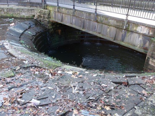
Thank you for the comments folks. Manchester is indeed a great city with a wealth of history to seek out. I found this pic showing the decay on the 1894 viaduct! The view is looking down from above. The channel at the bottom has become a corrosive water trap. It held the transverse bearers to support the deck plates and the attached rails. I'm gutted over the probable loss of the United Downs Raceway at St.Day. If we are fortunate enough to get some meetings in please try and pay it a visit before it's gone for ever. I know it's a long haul to get there but so worth it just to see the unique five cornered pasty shaped track.
-
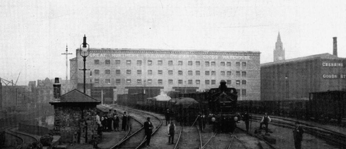
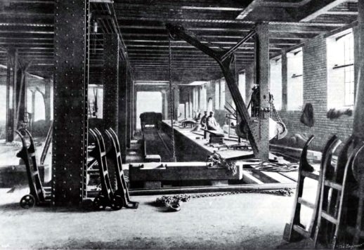
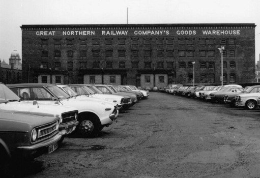
Continued from above: Our final stop is a short 5 minute walk to a marvel in mild steel and brick. The Great Northern Railway Company’s Goods Warehouse. A very early view of the warehouse with the Cheshire Lines Committee goods station to the right. (Pic credit to the Great Northern Warehouse) This was a former railway goods warehouse situated on Deansgate. Five storeys high, it was built above the Manchester and Salford Junction Canal. A dock beneath allowed goods to be transferred to and from the canal barges via shafts and a complex hydraulic lifting system. Trains arrived directly from the viaduct mentioned above. The building could hold 150 goods wagons across two levels with the additional capacity to stable a further 500 in its sidings. Inside the warehouse with a railway goods wagon at the entrance to the bay. (Pic credit to the Great Northern Warehouse) Its construction between 1896 -98 wiped out the district of Alport Town, which included 300 houses. 800 men were employed on the site. Fully fireproofed it used 25 million bricks, one and a half million granite sets, 50,000 tons of concrete, 12,000 tons of mild steel and a whopping 65 miles of rivets. The warehouse is a unique survivor of a goods exchange system involving the railway, canal and road networks of Manchester. It was considered in its day to be one of the largest and most advanced. In 1954 the warehouse closed and found use as a car park. Large areas of the site remained derelict. In 1979 the building was given grade ii listed status, followed by the closure of the car park in 1989. A comparison to the earlier external view. The tracks having been lifted to turn the area into a car park. No doubt the majority of these cars have long since been turned into cubes. (Pic credit to the Manchester Evening News) Consent was given to turn it into a leisure complex in 1996. Despite having listed status the development resulted in the demolition of the carriage ramp, much of the train deck, inclines and offices. Funny how big money can overrule things isn’t it? In 2018 planning consent was granted for further redevelopment. It is now home to a cinema, casino, restaurants, bowling alley, bars, gym, and a multi-storey car park. That’s it folks. Well done if you’ve made it to here. Thank you for joining me on our look around this incredible area. It’s well worth spending a day here if you get the chance in the future. Plenty of pics in the gallery. Next time: Chaos at Caister Road when the 2L National Saloons made their August visit to Yarmouth, plus the first in a two part look at a collection of immaculately preserved transport.
-
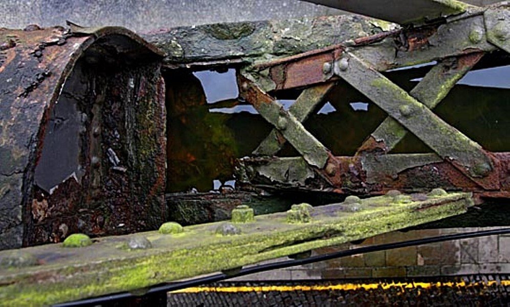
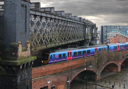
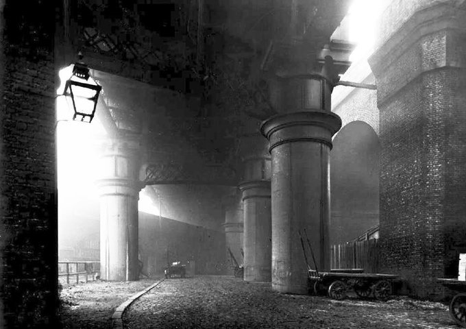
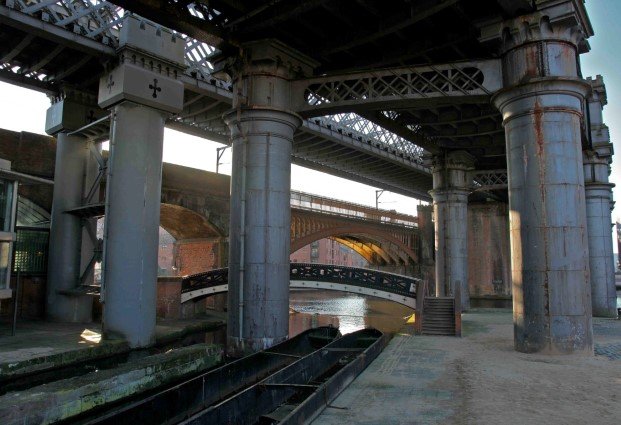
Continued from above: We now come to the truly and utterly wonderful vision that sits on top of the canals and dominates the whole place – the railway!! Castlefield saw the first passenger railway station in the world open in 1830. The Liverpool-Manchester Railway had their terminus at Liverpool Road station. It was here that divided facilities for rich and poor first appeared. There were separate sets of stairs up to the first floor waiting room and platform. There was a sundial over the entrance which was used for the train timetable! After 1844 Hunts Bank (now Manchester Victoria) came into use. Liverpool Road then became a goods station until closure in 1976. It now houses the Museum of Science and Industry. The new railway companies needed access to the city through the built up areas. Only one option was available to them here – the building of viaducts to carry traffic over the city. The negotiations to secure land rights for the railway were so drawn out that the company solicitor had a nervous breakdown! The canal basin is crossed by four large railway viaducts. ‘Castlefield Viaducts’ is the unofficial term used here regarding this impressive series of structures. The viaducts chopped the Roman site into pieces. An interesting feature of two of these is the way the piers are topped with mini-castles. Here’s a classic case of Victorian thinking - destroy the site of the fort but show where it once was by the addition of these castles. They were built in four phases over a period of 50 years to bring the railway into this crowded area. These viaducts are still the engineering beauties of Manchester. We’ll have a look at each one starting with the lowest. The Salford branch viaduct: On the 1849 viaduct a Deansgate bound train passes underneath the 1894 viaduct. (Pic credit to Forgotten Relics) This one is separate from the others and was built in 1849 by the Manchester South Junction & Altrincham Railway. It uses a brick arch to cross over the basin. The later giants were built across the top leaving this looking somewhat dwarfed. It is elevated entirely on more than two miles of viaduct, comprising 224 brick arches with their foundations extending 35ft below ground level. 28 cast iron bridge sections cross streets and canals. This is an active line going between here and Ordsall Lane Junction. The second 1849 viaduct: The southern viaduct in the group of three was also built by the Manchester South Junction & Altrincham Railway in 1849. Manchester London Road railway station (today’s Piccadilly) was opened in 1842. It was the terminus for two lines approaching the city from the south and east: The Manchester and Birmingham Railway from Stockport and Crewe, and the Sheffield, Ashton-Under-Lyne and Manchester Railway which at that time only ran as far as Godley, but would eventually reach Sheffield via Woodhead. Even in those early days it was clear that this dead end terminus would benefit greatly from a connection to other lines serving Manchester. The two companies proposed an extension which would skirt the southern part of the city centre and join up with the Liverpool and Manchester Railway at Salford. This was to become the South Junction line with a branch leaving at Castlefield via the first viaduct mentioned above. During the building of the line a viaduct collapsed when the scaffolding was removed. Three men died and two were injured. Five days later another two arches failed. Slow setting of the mortar in wet weather was the accepted reason. The opening of this line effectively created Sale, Timperley, Altrincham and Hale which all became the world’s first railway dormitory towns. The line later branched off to Liverpool. It remains the main Manchester-Liverpool link today. The 1877 Cornbrook viaduct: The central one in the group of three is the high-level iron truss girder viaduct built by the Midland Railway for the Cheshire Lines Committee. When it opened it carried trains from a temporary station to Irlam and Warrington. Manchester Central replaced this temporary station and eventually main line trains from London used this route into the city. Cast iron cylinders form the supporting piers. Unusually they are elliptical rather than circular. Owing to their large size this was deemed to be the strongest option. They are firmly bedded in the rock to a depth of 18 feet below ground level and filled with concrete. The wrought iron lattice girders are capped by castellated turrets. The manufacturer of these girders and piers was the firm of Eastwood, Swingler & Co. at their Victoria and Railway Ironworks, Derby. Their 28 acre site employing 1200 men gave them immense capabilities, and they had worldwide contracts to build all types of construction involving the use of ironwork. One order alone was for 235 bridges for the Indian Government. Derby Corporation acquired the works after closure in 1925 for the use of tram and bus sheds. It would be so easy to go off at a tangent here such is the history of this company. The engineering difficulties in constructing this viaduct over the 1849 viaduct and thickly populated district were met with typical Victorian ingenuity and satisfaction. One of the main objectives was to carry the line over the coal wharves leaving nothing in the way of working these wharves. Manchester Central closed in 1969 and became the G-Mex. The viaduct stood derelict for many years until refurbishment in 1990/91. It is currently used by the Metrolink tram system on the Altrincham route. The 1894 viaduct: A magnificent colossus of the Cheshire Lines Committee built for the Great Northern Railway. When the 1877 viaduct (above) opened it was carrying 120 trains in an 18 hour period. Within 7 years this soon increased to 300 trains. A relief was desperately needed to alleviate the traffic that backed up on the approach. A solution was the creation of this mammoth wrought iron structure. Extensive areas of built up land had to be cleared to make room. The foundations had to be of a great depth to bear the huge mass of iron and steel involved, not to mention the weight of the trains passing over it. The steel latticed viaduct’s main girders are supported on 15 cast-iron cylinders, each 10ft. 6in. in diameter, increasing to 13ft. 6in. at the base. The cylinders are embedded in Portland cement and rest on solid rock 20ft. below the surface. The longest column is 80ft. The widest span is 175ft. and one of the largest and finest in England. Underneath the 1894 viaduct. A wonderful photo from the past. (Photographer unknown) Here are some mind-boggling facts: The cast-iron columns weigh 2000 tons in total, 12,500 cubic yards of concrete were used in the foundations, and 1,500 cubic yards in the arches. 42,000 cubic feet of stone for the cylinder beds, 24 million common bricks for the arches and foundations, and 6 million Staffordshire blue engineers bricks for facing and buttresses. The total weight of iron and steel is 7000 tons, and 6 million rivets hold it all together. 600,000 of these were clinched by hydraulic power. All the varying difficulties were successfully overcome. In the initial excavations an old tunnel that had been constructed years earlier for the diversion of the River Medlock was directly in line with the planned layout. It was solved by the construction of a thick brick arch over the tunnel and one of the cylinders supporting the viaduct firmly embedded in concrete on top. The steel and ironworks were contracted to Heenan and Froude of Newton Heath. Another great engineering company with worldwide achievements, their most famous creation being the 518ft. Blackpool Tower. There was no interference to any other rail traffic whatsoever during the whole construction period. The completion of the viaduct was marked by a ceremony at the mid-point of the structure. Various dignitaries and engineering staff were invited. There was a presentation by Heenan and Froude to Mr.Scott, the chief engineer of the Cheshire Lines Committee of a mahogany case lined with satin, and containing two silver plated hammers, and two rivets, one gold and the other silver. The occasion was marked by the fixing and clinching of the last rivet. A copper rivet was placed in the only remaining slot, and duly clinched by Mr.Heenan, and Mr.Scott. I have been up on the viaduct to try and locate this copper rivet but the layers of paint applied over the years have long since hidden it. It’s a case of a quick on and off as CCTV and the Metrolink right alongside don’t make for a leisurely mooch about. On opening of the viaduct the three new tracks served Manchester Central and the adjacent Great Northern Railways Goods Warehouse. Upwards of 500 trains every 24 hrs was now met without any delays even in the busiest seasons. With the closure of Manchester Central and the goods warehouse the viaduct has stood abandoned ever since. When the Metrolink route was being investigated this viaduct was found to be in a poor condition. Time, a lack of preventative maintenance, and Manchester’s notorious weather have not been kind to the structure. Loose corrosion, botanical growth and vegetation had to be removed by descaling. The forged bolts and fittings have become rusted. Waterproofing measures have been carried out on the critical sections. The running rails were fastened to deck plates which have now formed a corrosive water trap. Halting the decline of this grade two listed giant clearly matters as a major ongoing water proofing exercise subject to funds is in place. We’ll leave these iconic structures now and take a walk over to the Giant’s Basin. The Giant's Basin We are heading back to the 1760’s for this wonderful relic from the age of the canals. It was the world’s first canal weir. Have you noticed a recurring theme of ‘world’s first’ here? The Bridgewater Canal met the River Medlock at this location and the weir took the overflow from the canal into the river. It takes the form of a 23ft. deep, 23ft. wide circular sump. An ingenious solution to overcome the problems associated with the fluctuating water levels. Continues below:
-
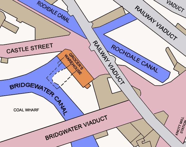
Continued from above: So that’s a short run through of the area’s past. We’ll have a walk now and have a more in-depth look. It is a fantastic place for railway architecture. The pics in the gallery follow some of this tour around. Let’s go! In a few places there are signs of the bedrock on which the area rests. Known as Collyhurst sandstone it is a faded or deep red colour. This can be seen in some of the exposed river cliffs. It provides firm foundations for multi-storey buildings and was easy to cut tunnels and culverts through. Prior to 1750 roads were not suitable for the movement of goods so water was used for transportation. Water was also harnessed to power machinery but required a fast flow. Situated between two rivers Castlefield had the potential to be in the prime spot. The River Medlock could be used to turn the waterwheels as it flowed down to meet the River Irwell. However, the Irwell would need to be improved for navigation. Eight locks were constructed along this, and the Mersey, with short cuts dug to eliminate the bends. This combined waterway became known as the Mersey and Irwell Navigation which was superseded eventually by the Manchester Ship Canal. The Bridgewater Canal was the world’s first true industrial canal. It was constructed originally to transport coal from Worsley to Manchester and opened fully to Liverpool in 1766. Coal fuelled the furnaces and fired the engines of Manchester’s mills and factories. Demand was enormous and by the late 1700’s 40,000 tons were shipped here each year. The Rochdale Canal reached Castlefield in 1802 and was the first trans-Pennine canal. This in turn was connected to many private canal arms from mills and major warehouses in the Peak District and Derbyshire. One important cargo was limestone to be used in the erection of buildings. Within ten years of completion the Rochdale was bringing more than fifty laden boats here into the basin every day. At least another three canals were dug out locally to interconnect throughout the Castlefield basin. All of these were unsuitable for large vessels however so to gain direct access to the sea the Manchester Ship Canal was designed. In its day this was the largest navigation canal in the world. Trans-shipment from the inland barges to the ocean going vessels was carried out at Salford Quays and Pomona Docks. There were at least ten major warehouses contributing to the commerce of the area. A couple were destroyed by fire and subsequently rebuilt. Goods in storage included maize, oil, cotton, grain and flour. One feature to see as we walk around is the Grocer’s Warehouse. The position of the warehouse within the Castlefield basin. (Map credit to Manchester History) The five storey building was constructed on the quayside. Twin tunnels underneath were dug out from the canal into the cliff face. A 50ft shaft was dug from the street above down to the water level. Boats would approach from the canal and enter the tunnels. Cranes powered by waterwheel were used to unload goods to each of the levels within the warehouse. With a complex system of sluice gates, geared wheels, axles, winding drums, ropes and chains the workmen could lift heavy goods, and stop and start the lifting at each floor. They also tied themselves to the lifting mechanism to move between the levels! This was the first British warehouse where barges were unloaded inside by water powered crane. A cut-away view of the warehouse. (Pic credit to Manchester History) Continues below:
-
Hi there folks, Welcome to our first get together of this off season. You’ll need two brews for this one. This week we’re heading for Manchester. We’ll be taking in the never to be forgotten sights of Castlefield. It is one of the most historically important areas in the world. A dramatic urban landscape with a tangle of waterways and railways, suspended on many levels. Castlefield's bridges and viaducts It is the birthplace of Manchester and holds the city’s Roman origins in Mancunium, canals that drove the Industrial Revolution, and the world’s oldest surviving railway station. The Castlefield viaducts are excellent examples of the 19th century attitude to engineering challenges. Their dramatic almost medieval style is complemented by the gothic arches in the iron bridges, and the castellated turrets on top of the structures. Castlefield for me is pure drama where steel, iron and brick meet head on. There is a huge amount of history around here. We’ll look further into certain aspects of the site later. Its name is derived from its position below a Roman fort. Campfield, and Castle-in-the-field are earlier names associated with it. The fort was about five acres in size and guarded important routes to and from Chester, the Cheshire salt workings, and York. The site was abandoned by the Romans in the 3rd century and the village of Manchester became established a short distance further north. The area became the estate of the Mosley family. By 1601 a substantial house and park had been created only to be burned down by Parliamentarians during the Siege of Manchester in 1642. By 1720 the River Irwell had been made navigable and a quay was constructed in the area. Ships of up to 50 tons could dock here on this trade route between Manchester and Liverpool. In July 1761 the Bridgewater Canal arrived, joined soon after by the Rochdale Canal, and a network of other private waterways. A connection to the Mersey and Irwell Navigation saw the canals reign supreme. The Industrial Revolution was said to have started at this time. Engineering works and warehousing were the primary industry here along with a smaller trade involving the cotton mills. In 1771 the first canal warehouse was built on Coal Wharf which was used to raise coal from the barges to street level (see the Grocers’ Warehouse later to find out how they did it). Prior to this the coal had to be taken by cart uphill to the street. The railways arrived in the 1830’s to end the domination of the canals. The area became dissected with a multitude of railway lines and multi arch-viaducts. A system developed whereby warehouses became trans-shipment centres. Trains and barges would arrive and their loads sorted to be shipped to other destinations. Other warehouses would be used for receiving yarn and raw cotton goods which would then be taken by outworkers and returned as woven cloth. During the 20th century both the canals and railways declined and the area became derelict. During the 1980’s the site was designated as an urban heritage park. As part of the renewal an outdoor events arena has been constructed, and plenty of bars and restaurants have sprung up which in normal times are extremely popular. New office blocks and apartments have been built around the site but thankfully do not intrude on the former heart of the industrial scene. Map credit to Wikiwand Continues below:
-
A Sunday treat - Stavros shows us what's in at Scania dealers T.Nolans in the Emerald Isle. CHEEEEERS!! See you all next weekend for our first off season get together
-
Cheers for the info John. You'll have to show me those remains next time we're there. It sure looks strange with nothing around it when the track was being constructed.
-
I think you're spot on there Mick regarding the trainees building it. That particular part of the site was at the back of the brickworks and there was a fair few bricks left behind when the works closed. It was a good opportunity to clean up the site and let the trainees loose on the pile. They've made a fine job of it too. Very artistic. Regarding the Garrison i did have a walk down there once before a meeting but it had already closed. One pub that always makes me smile when i think back was the Traveller's Rest, a Hydes house near to the old Belle Vue on Hyde Road. It had a sign in the window saying 'locals only' which somewhat contradicted the pubs name! I did venture in and remember Dire Straits' Sultan of Swing was playing on the juke box. This was in the early 80's and they had mild at 50p a pint and bitter at 56p. There was some young whippersnappers hanging around outside who offered to watch our car for 10p whilst we were at the track. We obviously paid up.
-
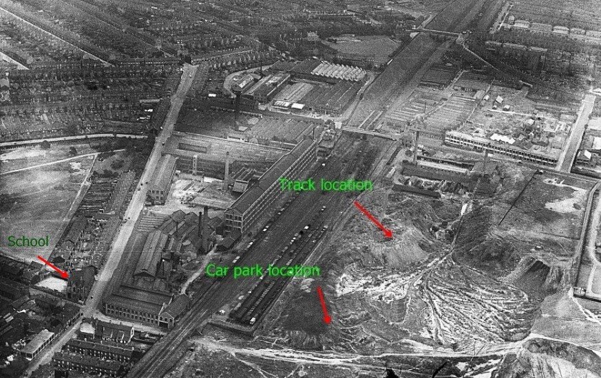
continued from above: This image with permission and licence from HES Archive We finish with this super aerial shot from 1931 which shows the Adderley Park Brickworks and the Wolsley Tool and Motor Car Works. At the crossroads bottom left of the pic the school still stands to this day. The buildings either side of the Wheels access road opposite have long since gone. I’m sure you’ll agree a lot of history in a very small area. Join me next time for the first of our winter season journeys and we’ll have a look around one of the most distinctive and historically significant urban landscapes in the United Kingdom.
-
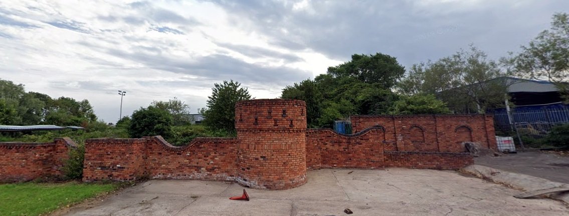
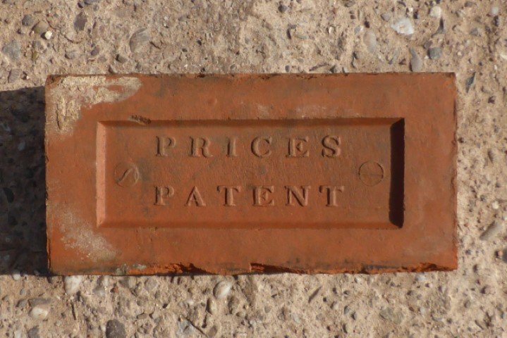
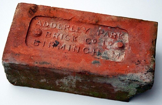
continued from above: The car park we use is on the site of the Britannia Brickworks opened in 1862 by James Price. Access to the works was via the same road we use now. However, back then the road was purely for the brickworks and did not continue any further as it does today. The bricks were taken from here to a storage yard two miles away in Chester Street. This was adjacent to the Birmingham & Fazeley Canal which was used for distribution. After a couple of ownership changes the Midland Brick Co (as at the Garrison Farm works) became the last owners. The site closed just after WW1 in 1918. James Price was the first owner Finally we come to Adderley Park Brickworks which is where the track now stands. Opened in around 1870 the site was a summer yard, working in the open. In most of the Birmingham yards the clay was dug out in the autumn, then ‘weathered’ and turned in the winter. In the following spring and summer it was hand moulded, after being trodden by foot or ground in a horse mill. Life in the brick yards was hard with extremely miserable conditions. Some of the brickmakers became maltsers and brewers during the winter to offset the lack of income. Manufactured on site Eventually the Adderley Park works were modernised with the erection of a steam grinding mill, and coal-fired drying sheds. This vastly improved the quality of the facing bricks turned out by this works. The clay was dug on site, and with the addition of sand and other materials was manufactured into bricks, tiles, and pipes. The lease on the land had strict clauses: “It must be well fenced, not make less than three million articles per year, the clay must be dug in a regular and workmanlike manner, erect no buildings within 30 yards of the public highway, and at the end of the lease return the land to as good a condition as a brickfield will allow”. A further stipulation at this particular site was the construction of a tunnel and tramway to transport clay and sand from another site nearby. By 1902 this additional site had been taken over by the Wolseley Car Company to test their vehicles on the rough terrain. In 1920 Wolseley filled in and levelled the site and built their East works. As to the main works this remained in operation up until 1946. Scrap metal merchants then took over part of the site. Next time you go to Wheels have a look at the brick structure on the left just at the start of the uphill pit road. This is made of old bricks recycled from the remnants of the works. This whole area of Birmingham has a fascinating history and the brickworks are just a small part of it. Gas works, engine sheds, railway carriage and wagon works, paper mills, rolling mills, wire mills, rope and hemp works, varnish works, screw works etc. Within a ten minute walk from the track was the Universe Rope Works. They patented the cable for the Atlantic & Undersea Communications in 1866 which was laid between Ireland and Newfoundland. In the process of running the factory they would at odd times carry out some unknown operation that resulted in all of the local residents getting bitten by fleas! This works in later years was used as a Land Rover plant and produced all the welded chassis frames. It was a perfect set up as the long lines previously used to draw the wire ropes were ideal for the layout of the welding lines. How times have changed. A few of the original buildings still survive, but sadly the area is now not even a shadow of its former self. continues below:
-
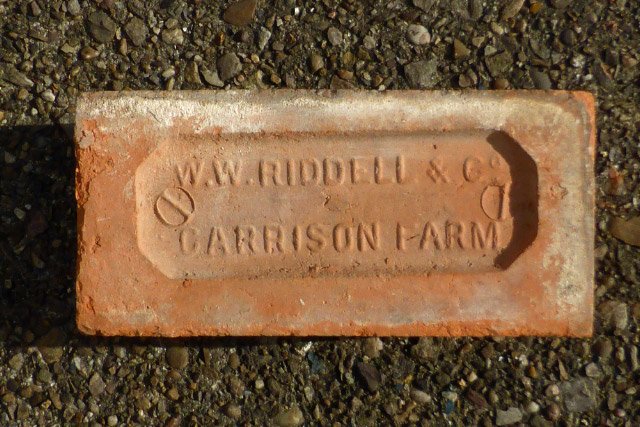
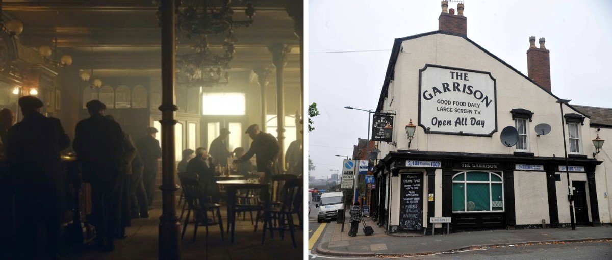
continued from above: The track is built on land once occupied by Garrison Farm. It took its name after the Civil War when Prince Rupert’s Royalist troops set up camp here in 1643. The name of the farm is recalled in nearby Garrison Lane, a ten minute walk from the track. On this lane is the Garrison pub. Do any of you watch the tv series Peaky Blinders? If so, you will be familiar with this. Although the show used a stage set this real Garrison pub was frequented by the Peaky Blinders at the turn of the 20th century. Pic credit to the BBC and the Birmingham Mail Sadly the Garrison no longer plays host to anything as interesting. It was sold for £183,000 in 2014 and a plan submitted to turn it into flats. The Digby family became the owners of the former arable farm land in the mid 1800’s. They leased many small plots to individual brickmakers who used clay which was dug on site. These small yards were eventually combined into the larger Garrison Farm Brickworks. The go-kart track now stands on this site. The brickworks had various owners over the years who all made good use of the nearby Birmingham and Warwick Junction Canal for distribution. The finished bricks were moved by barrow from the kilns to the waiting barges. This works was also served by the railway with a siding connecting it to the London & North Western Railway. Only authorised personnel could go over the level crossing which was known locally as “Brickworks Crossing”. The Midland Brick Co. were the last owners when the works closed in 1936. By 1938 only the clay pits remained. Courtesy of the Chris Thornburn colection Riddell was one of many owners at the Garrison Farm works continues below:
-
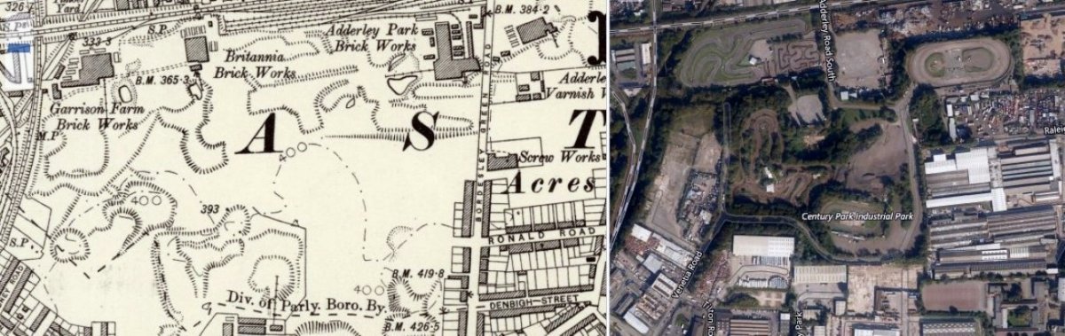
Hi there folks, Well the mini season was so close to making it to the last meeting. We did very well to get that far against all odds. Many, many thanks to all involved. Fingers crossed for 2021. Now it’s about time to start our winter season journeys off that beaten track once again. Our industrial and historical heritage is fast disappearing under a sea of housing and regeneration. It is literally a race against time to capture a brief look into the past. Let’s start for now though with a look at another race track in the ‘What was there before?’ series. To celebrate its saving we start off this week with the early days of the Birmingham Wheels site. This side by side image shows the site in 1888 & 2020 Image credit to NLOS continues below:
-
Within days folks. The ghosts of the past are waiting for us along the disused railway line, at the end of the tunnel, and within the walls of the derelict building. They will walk with us again off that beaten track.
-
Pics now in the gallery
-
Thank you Jane and Darrelle. It was a wet'un by the sound of it. JJ's second Final win in adverse conditions following on from that extremely wet Belle Vue in April 2018.
-
Gates open at 10 tomorrow DJB
-
No pit access today folks
-
Yes, thank you Ben and Nic for last week 👍
-
Skegness Results - Saturday 19th September 2020
Roy B replied to nic's topic in Essential Information
Hope this cheers you up Jane. He behaved himself tonight. Hope you feel better soon.
.jpg.cd3833d245c588c5725b8a7f31490f23.jpg)
.jpg.65877846fcef34217a9af1825469102e.jpg)

.jpg.a84e4b56f57e21807cfaab99f254bd85.jpg)

.JPG.512b82f9beddd14f2fec35affdbe6886.JPG)
.JPG.9f5517046b693de819caec3c7de0469d.JPG)

.JPG.1c9c21631ead5ed0ff9c18fc8a40e6fe.JPG)
aammm(Custom).jpg.2795196a9d299fe0bd0f5c60ff01df8b.jpg)

.JPG.31d720d2070033aed6929f2be2df28f2.JPG)